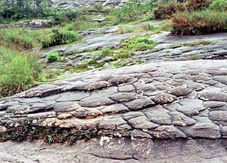
Phu Hin Rong Kla National Park, Phitsanulok, Thailand
Generally steep mountains. The park borders with Laos in the northern part, in Chaiburi dstrict. The southern part of the park runs into Phitsanulok province in Thailand. The mountain range includes the peaks of Phu Pangma, Phyu Lomloh, Phu Hin Rong Kla and Phu Mahn Yow, the tallest in the park at 1,800 meters above sea level. The second tallest in the park is Phu Lomloh at 1,664 meters. The park is the source of headwaters of many streams including Huay Muad Kon and Huay Luang Yai.
 The climate is similar to that of Phu Kra Dung and Phu Luang. Because of its high altitude, the park is cool all year round, especially in the cool season (November to January) when temperatures can occasionally drop to near freezing point.
The park has mixed deciduous, dry dipterocarp, dry evergreen, and hill evergreen forests. The mixed deciduous forest tends to be spacious and open. Tree species commonly found include Dipterocarpus obtusifolius, Shorea obtusa, Shorea siamensis and Dipterocarpus tuberculatus.
The dry evergreen forest has better and moister soil, particularly in higher elevations and along the streams. Species include Dipterocarpus alatus, Hopea ferrea, Hopea oborata, Anisoptera cochinchinensis, Dalbergia oliveri, Chukrasia venlatina, bamboo, and Brahm among others.
Hill evergreen forest is seen at higher elevations of 1,000 meters and up. Species tend to be soft woods. Important species include Dacrydium elatum, Betula alnoides, Eugenia cumini, Anneslea fragrans Podocarpus imbricatus and Pinus merksii P. kasiya.
The sandy flat areas on ridge tops support Sphagnum recuryum, algae and perennial plants such as Burmannia disticha and Osbeckia chinensis. In addition, may orchid species can be found in rocky areas, including Lycopodium phlegmaria and rhododendron. These flowers bloom between the rainy and cool seasons, in November.
It is believed that the park areas, in the past, had a large diversity of wildlife. During the years of fighting between the communists and government forces a lot of forest area were disturbed and much of the wildlife was gone. Remaining wildlife includes tigers, leopards, Asiatic Black Bears, wild boar, fox, monkeys, leopard cats, wild hare and many bird species such as boves barbets, common Flameback, Asian Barred Owlet, Brown Hawk-Owl, jungle fowl, bulbuls, and swallows.
Highlights and tourist attractions
Communist headquarters: Three km from the park's headquarters are located the former office buildings from which the communists insurgents carried out their administrative functions. There are a cafeteria, cloth shop, meeting place, jail and intelligence center.Villages: There are villages with 40 to 50 houses each. The houses are small, having dirt floors and wooden tiles roofs. Each house has a dug out area used to hide during the air raids.
Hospital: Two km from the headquarters was a hospital equipped to treat the sick and injured. Doctors could perform a variety of minor surgeries. China provided training, technical assistance, and intensive courses. Among the remaining artifacts were Chines medical texts.
Lan Hin Tak: 300 meters to the west of the Thai army headquarters (Than Pacharin) is Lan Hin Tak (broken rock field). Along the path, growing in rock crevices, are various plant species including mosses, ferns and ground orchids. Peering into the depth of crevices can be eerie. Some crevices are narrow enough to jump across. Loud echoing of running water below can be heard in several of them. The crevices could have been used by the communists as hiding places.
Lan Hin Pum: About 4 km from the park's headquarters, near the cliffs, is a field of nodulated stone, Whose lumps are roughly equal in size. It is believed that this formation resulted from physical and chemical erosion. Patients from the hospital suffering from fever would used the area as a rest spot, as a cool breeze blows over the area almost continuously.
Flag-ple cliff: A steep cliff overlooking a valley to the west. The communists used this cliff to fly their red flag after each victory over the government forces.
Romglao and Paradon waterfalls: Romglao waterfall is located 5 km from the park's headquarters. As you approach the road to the School of Military Politics, the path to the waterfall is on the left and leads about 1 km off the road to the waterfall. The forest in this area is in a healthy condition with many large trees. A side trail leads to Paradon waterfall, which is a downstream of Romglao waterfall.
Sripachrin waterfall: This medium-sized waterfall is located about 600 meters off the road, near Huay Namsai village.
Ganglad and Tadfa waterfalls: Set at the foot of Phu Hin Rong Kla, Ganglad is located about 2 km from Huay Namsai. At the base of the fall is a small hydro-electric generator. If you climb 3 or 4 km further up the mountain, you will reach Tadfa waterfall (also known as Tan Gawsahng waterfall), an impressive, towering waterfall.
In addition to these spots there are many other interesting places there.
Source : Trek Thailand


0 Comments:
Post a Comment
<< Home